


croix de jaume

michel38
User
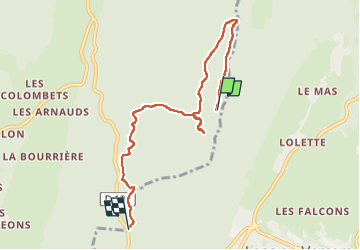

Length
6.7 km

Max alt
1635 m

Uphill gradient
142 m
Km-Effort
9.6 km

Min alt
1212 m

Downhill gradient
454 m
Boucle
No
Creation date :
2025-05-26 09:10:59.161
Updated on :
2025-05-26 12:02:28.08
2h50
Difficulty : Medium

FREE GPS app for hiking
 SityTrail
IGN / Geographical institutes
SityTrail Plus
The world is yours!
About
Trail Walking of 6.7 km to be discovered at Auvergne-Rhône-Alpes, Isère, Autrans-Méaudre en Vercors. This trail is proposed by michel38.

Positioning
Country:
France
Region :
Auvergne-Rhône-Alpes
Department/Province :
Isère
Municipality :
Autrans-Méaudre en Vercors
Location:
Méaudre
Start:(Dec)
Start:(UTM)
702463 ; 5002282 (31T) N.
Comments